Spot settings for your sport and skill level
VamoSpot marks in green the hours when the forecast wind suits a spot. The default settings are general estimates. Once you adjust the wind direction, minimum wind and sun setting for yourself, green means conditions that suit you.
How VamoSpot decides whether there are conditions
Every spot has two conditions: the wind direction (a sector in degrees) and the minimum wind (m/s). VamoSpot compares them with the forecast wind, hour by hour.
- Green, surf conditions: the forecast wind is at least the minimum, and the direction is inside the sector.
- Amber, borderline: the wind is at most 1.5 m/s below the minimum and the direction is at most 15° outside the sector, or the wind is strong enough but the direction is at most 25° outside the sector.
- No surf conditions: everything else. If the sun setting is on, the hours of darkness are left out too.
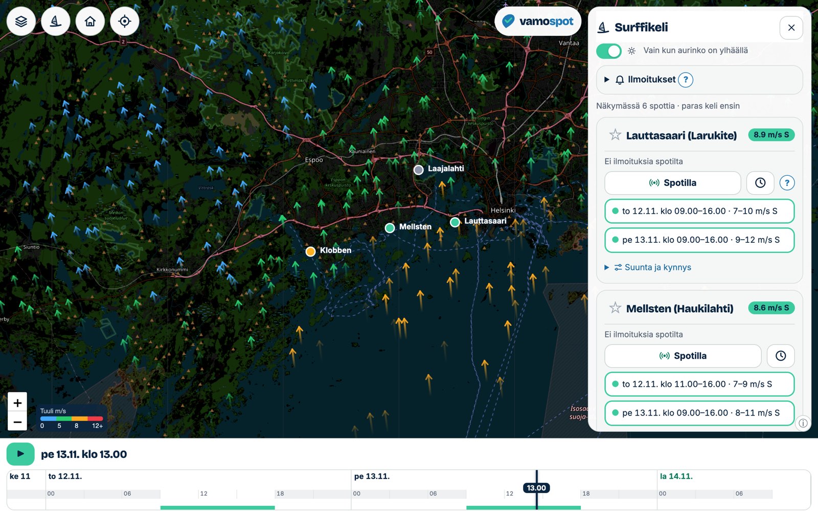
The same assessment appears in three places in the app. When you change a setting, all three update straight away.
 123
- Spot card: green time windows show when the spot has conditions, and amber ones when conditions are borderline. Tap a time and the map moves to that spot and that moment.
- Map: a spot's circle is green if there are conditions at the selected moment, amber if conditions are borderline, and grey if there are none.
- Timeline: the strip along the bottom is green in the hours when any spot in view, or one of your favourites, has conditions, and amber when conditions are borderline. Drag the timeline and the map shows the selected moment.
There is no upper limit. VamoSpot does not currently warn you about wind that is too strong, or about gusts. Green means there is at least as much wind as you have set, not that conditions are safe. Always check the wind strength and the gauge's gusts yourself before you go out.
Where to find the settings
- Open Surf mode. On a computer the spot list opens in a side panel; on a phone, from the spots button in the top corner of the map.
- Move the map so that the spot is visible. The list shows the spots in view and your favourites, best conditions first.
- On the spot card, open Direction and threshold.
- Change the From °, To ° and Min m/s fields. The compass graphic shows the selected sector in green.
- To go back to the original values, press Reset to default.
The settings are per spot, so you can set separate limits for each spot.
Wind direction
Direction always means where the wind is coming from. Degrees follow the compass: 0° (or 360°) is north, 90° east, 180° south and 270° west. A south-westerly wind is about 225°.
The sector runs clockwise from the From ° field to the To ° field. For example, 120–240 means winds from the south-east round through south to the south-west. The sector can also cross north: 300–30 means winds from the north-west round through north to the north-east.
How to choose the sector
- Look on the map to see which way the shore faces. Wind from the sea, or along the shore, is usually what you are looking for.
- Leave out directions in which the wind blows from the land out to sea. The wind then carries you away from the shore, and wind that has come over land is gustier: according to the Finnish Meteorological Institute (FMI), gusts over land are about 1.6–1.8 times the mean wind, and over the sea about 1.2–1.3 times.
- Leave out directions in which the wind comes from behind a forest, buildings or islands. Even a small obstacle creates eddies in the air.
- If you are not sure, start with the default sector and narrow it according to which days have been good.
Some of the default sectors are based on published spot guides; others are estimates. Your own experience of the spot is a better source.
Minimum wind
Min m/s is the lowest forecast mean wind at which the spot shows green for you. The default for all spots is 7 m/s.
The wind figure in the forecast is the mean wind, not the gusts. Gusts are usually noticeably stronger, and the wind varies locally. There is more on this in the guide Which wind forecast works on the water?
How to choose the minimum wind
- Think about the mean wind at which you can get going on your own kit and keep going. A bigger kite, wing or sail and a lighter rider manage in lighter wind.
- Compare after a few sessions: what did the wind gauge or the forecast show on the days that were good for you? Adjust the limit to match.
- Amber, "borderline", shows the hours when the wind is a little below your limit. If you often go out on amber, lower the limit. If green is often not enough, raise it.
- If you use different kit at the spot on different days, set the limit for the kit that needs the least wind, and check the strength yourself.
Sun: daylight hours only
At the top of the spot list there is a switch, Only while the sun is up. It is on by default.
- On: conditions are only calculated between sunrise and sunset at the spot's own location. Hours of darkness never turn green, and in the spot's pop-up they are shown with a moon symbol and the text "sun has set".
- Off: night-time hours can be green too.
The setting applies to all spots and to notifications as well. There is no per-spot sun setting. The daylight limits are sunrise and sunset, so evening twilight falls outside the green.
Favourites and notifications
The star ☆ on a spot card makes the spot a favourite. Favourites appear at the top of the list even when they are not in the map view.
To turn on notifications, go to Notifications → Notify me of new surf conditions at ★ favourites in the spot list.
- You get a notification when a new unbroken green period of at least two hours appears in a favourite spot's forecast within the next four days.
- Notifications use your own direction and minimum wind settings and your sun setting. Amber "borderline" hours do not trigger a notification.
- You get only one notification for the same window of conditions.
- On iPhone, notifications only work once VamoSpot has been added to the Home Screen (Safari: Share → Add to Home Screen) and opened from there.
- If your browser does not support notifications, the ntfy app is available as a backup in the same menu.
Forecast model and wind gauge
Conditions are calculated from whichever forecast is selected under Forecast model in the Layers menu:
- HARMONIE 2.5 km: a more detailed model for the next few days.
- ECMWF: a coarser model that reaches ten days ahead.
The differences between the models, and when a new forecast run reaches the site, are explained in the guide How are weather forecasts made?
When you switch model, the spots' time windows are recalculated. The differences between the models, and which one is worth trusting when, are explained in the guide Which wind forecast works on the water?
Spots with a wind gauge nearby show the gauge reading and gust on the card. If the gauge's average over the last hour differs from the forecast, VamoSpot corrects the spot's forecast for the next few hours by the difference. The card then says "Forecast corrected by gauge". The correction weakens hour by hour, because a measurement only tells you about the next few hours.
Examples
Beginner kitesurfer
Narrow the sector to directions in which the wind comes from the sea or along the shore, and remove all directions in which the wind blows from the land. Set the minimum wind to a wind at which your own kite is sure to pull, and do not lower it right to the limit. Because there is no upper limit, check the wind strength and the gauge's gusts yourself for the green window. Keep the sun setting on.
Wingfoiler
A foil gets you going even in lighter wind, so you can lower the minimum wind to suit your own wing and experience. You can keep the sector wider if the spot lets you get out on the water and back in several wind directions. The amber hours are often exactly the ones worth a closer look.
Gusty or steady wind
VamoSpot has no gust limit. If steady wind matters to you, leave out of the sector the directions in which the wind comes over land, forest or islands, because obstacles make the wind more uneven. On the day you go, check the gauge's gust reading on the spot card and compare it with the mean wind.
Settings on another device
Your settings are saved in the browser where you make them. To move them to another device:
- Open the Layers menu, go to Transfer settings and press Create code.
- Open VamoSpot on the other device, type the code in the same place and press Load.
The code transfers your favourites, spot settings, sun setting, layer choices, forecast model, base map and home view. The code is valid for 30 days.
Sources
- FMI: Tuuli ja myrskyt (kysymyksiä ja vastauksia) (Wind and storms: questions and answers, in Finnish): gusts, wind direction and the effect of obstacles
- The features and limits are described as implemented in VamoSpot itself.